Bengaluru’s urban expansion can be understood not only through its skyline but also through the pattern of layout approvals over time. Data from the Bangalore Development Authority (BDA) highlights how the city’s growth has gradually shifted across regions, influenced by land availability, employment hubs, and infrastructure development.
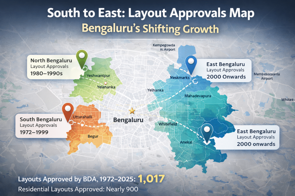
Over the period from 1972 to 2025, BDA approved approximately 1,017 layouts across Bengaluru. In the early decades, urban development was largely concentrated in South Bengaluru, which continues to account for nearly 40–43% of total approved layouts.
🏡 South Bengaluru: The Early Growth Anchor
During the initial phases of planned expansion, areas such as Uttarahalli, Begur, and Kengeri emerged as key development zones. These localities offered large land parcels and proximity to the city’s established core, making them suitable for structured residential growth.
The southern belt thus became the foundation for Bengaluru’s early organised urban development.
🏢 Northward Expansion: 1980s–1990s Shift
By the 1980s and 1990s, the city’s growth trajectory began to extend towards North Bengaluru. Regions such as Yeshwantpur and Yelahanka saw a noticeable increase in layout approvals, driven largely by cooperative housing societies.
This phase marked a transition where planned residential development expanded beyond the southern regions, reflecting changing land dynamics and population distribution.
🚧 Eastward Growth: Post-2000 IT-Led Expansion
A significant shift occurred after 2000, as development activity moved towards East Bengaluru and areas such as Anekal taluk. The emergence of IT corridors played a key role in this transition.
Previously considered peripheral, these regions began to gain prominence due to:
- Proximity to employment hubs
- Improved connectivity
- Increasing demand for residential spaces
This phase highlights the influence of economic activity on urban planning and land utilisation.
📄 Approval Process and Planning Dynamics
According to BDA officials, layout approvals closely align with infrastructure readiness and market demand.
Applications are reviewed by the town planning committee, and approvals are granted only after ensuring compliance with regulatory frameworks. In recent years, applications have been received from a wider range of locations across the city, indicating more distributed development activity.
🏘️ Dominance of Residential Development
A notable trend in BDA data is the dominance of residential layouts. Nearly 90% of approved layouts—approximately 900—are residential in nature. Industrial and commercial layouts account for a significantly smaller share.
This pattern is largely attributed to:
- Higher land requirements for industrial projects
- Limited availability of large contiguous land parcels within city limits
🏗️ Shift Towards Denser Development
Recent trends indicate increasing pressure on land availability, leading to a gradual shift towards vertical and denser development.
In 2025–26 alone, BDA received 179 plan approval requests for single and multiple plots. This suggests a move towards optimising land use, even as new layouts continue to be developed.
Additionally, nearly one in ten layouts has undergone revisions after initial approval, often to accommodate evolving infrastructure needs and design modifications.
📊 Conclusion
The pattern of layout approvals provides a clear representation of Bengaluru’s evolving urban landscape. From a south-centric expansion to northward growth and eventually an eastward shift driven by the IT sector, the city’s development reflects changing economic and infrastructural dynamics.
BDA’s data offers valuable insight into how Bengaluru has expanded over time—and how it continues to adapt to emerging demands and growth drivers.
⚠️ Disclaimer
This article is intended for general informational purposes only and is based on publicly available data, planning records, and general urban development trends. The content has been independently written and does not represent any specific publication.
Any references to locations, authorities, or development patterns are illustrative and do not constitute recommendations or factual guarantees.
Readers are advised to conduct independent research and consult relevant professionals before making any real estate or investment decisions. The author and publisher shall not be held responsible for any outcomes resulting from the use of this information.
Source: Adapted from various newspaper reports and urban planning insights.